
COME ARRIVARE A FERENTO DA VITERBO
Percorrendo la strada provinciale Teverina da Viterbo direzione Bagnoregio, al km 7 incrocio: non a sx dove c'è la zona industriale Acquarossa, ma a dx dove è indicato Ferento con cartello blu. Percorrere 1 km circa imboccando la strada a dx e si arriva al sito archeologico di Ferento. Al centro dell'incrocio che divide le due strade c'è una casa bassa ex ANAS.
ATTENZIONE!!!!!!!!!!!!!! DA CIRCA 15 LUGLIO A CIRCA 15 AGOSTO APERTURE SU PRENOTAZIONE PER SVOLGIMENTO STAGIONE TEATRALE. CHIAMARE PRIMA 3287750233 O MAIL A archeotuscia@gmail.com
Le rovine della città romana di Ferento si trovano su una lingua tufacea di forma allungata estesa una trentina di ettari, che si affaccia in modo davvero spettacolare sui torrenti Vezzarella e Acquarossa.
La città di Ferento era attraversata dalla via publica Ferentiensis, un’arteria trasversale che collegava la via Cassia con la valle del Tevere e che, passando per Ferento, ne costituiva il decumanus maximus.
Ferento romana nacque in seguito dell’abbandono dell’abitato etrusco di Acquarossa e assunse notevole importanza specialmente durante il periodo imperiale.
Infatti sappiamo da Tacito e Vitruvio che la città divenne municipium e che fu ascritta alla tribù Stellatina, ma soltanto in età giulio-claudia raggiunse il massimo splendore con l’edificazione di sontuosi edifici pubblici tra cui il teatro, l’anfiteatro, le terme e il foro che grazie alla generosità di due privati cittadini, Sesto Ortensio e Sesto Ortensio Claro, venne completamente riqualificato. Anche il decumano venne dotato di un largo portico colonnato sul quale si affacciava un grande isolato destinato ad attività commerciali.
Ferento venne fregiata del titolo di civitas splendissima, come ci ricorda un’iscrizione del II secolo d.C. rinvenuta nelle vicinanze, ma è anche famosa per aver dato i natali all'imperatore Marco Salvio Otone, che regnò nel 69 d.C., nonché a Flavia Domitilla, la moglie dell’imperatore Vespasiano e madre di Flavia Domitilla Minore, Tito e Domiziano, entrambi imperatori di Roma.
A partire dal III secolo d.C. le notizie su Ferento si fanno più incerte.
Dopo le invasioni barbariche divenne sede di diocesi almeno dal VI-VII secolo; con il successivo conflitto tra longobardi e bizantini per la città inizierà inesorabilmente un lento declino con conseguente calo demografico.
Nel corso dei secoli XI e XII Ferento sembra che si fosse organizzata in un’autonomia comunale con l’abitato che lentamente si era ripopolato. Ma il declino e la definitiva distruzione della città di Ferento avverrà nel 1172 ad opera dei viterbesi. Tale fatto sembra essere scaturito da continue rivalità tra i due centri sul controllo del territorio.
A seguito della distruzione di Ferento, una parte della popolazione si rifugiò in località “Le Grotte (attuale Grotte Santo Stefano) mentre ad altri fu permesso dai viterbesi di trasferirsi presso la zona di San Faustino.
Per meglio evidenziare l’annientamento della città rivale, aggiunsero al leone di Viterbo anche la palma, simbolo di Ferento, dando così origine allo stemma comunale viterbese che è ancora oggi così rappresentato.
LA CITTÀ DI FERENTO
LA SCOPERTA E GLI SCAVI
La scoperta di Ferento è legata al nome di Luigi Rossi Danielli, archeologo viterbese che insieme alla “Società Archeologica Pro-Ferento”, costituitasi nel 1906, condusse ricerche e scavi sul colle di Pianicara agli inizi del Novecento, effettuando lo sterro di gran parte del teatro e mettendo in luce il vicino impianto termale.
Tra il 1925 e il 1928 la Soprintendenza alle antichità di Roma completa la messa in luce del teatro e lo scavo restituisce tra le altre cose un prestigioso arredo statuario composto da nove Muse della mitologia classica (Melpomene, Talia, Erato, Euterpe, Clio, Tersicore, Urania, Calliope, Polimnia) che ornavano le nicchie dell’ordine inferiore del proscenio e una copia del Pothos del celebre scultore Skopas, collocato nella cavea del teatro (oggi a Viterbo al Museo Nazionale della Rocca Albornoz).
LE NECROPOLI
Numerose sono le necropoli che circondano Ferento, si conoscono la necropoli di:
- Procoietto: III-II secolo a.C., principalmente tombe a camera;
- Talone: IV-II secolo a.C.;
- Poggio della Lupa: famosa soprattutto per la Tomba dei Salvi, la famiglia che dette i natali all'imperatore Marco Salvio Otone, sepolcro risalente al II-I secolo a.C. Interessante è la presenza a circa 200 metri da questa tomba della cosiddetta “Miniera di Ferento", la galleria si sviluppa per almeno 50 metri sotto la rupe della collina, finalizzata alla ricerca di minerale ferroso, in genere limonite.
- Poggio della Lestra.
Ferento (English)
A short walk in the Roman world…
This city in Upper Lazio plays an important role among the few urban settlements that developed along the western bank of the central valley of the River Tiber: the (little known) story of an ancient residential and monumental complex as witnessed by an extraordinarily valuable archaeological area
Text and photography: Giovanna Ottavianelli
Ancient Ferentium is still there, eight km north-east of Viterbo, situated on the Pianicara, a large plateau of tuff rock, surrounded by ditches (Guzzarella, Vezza and Acquarossa). What we know today about this city, though far from being a complete picture, is the result of several explorations starting in the beginning of the 20th century, continued in various discontinuous excavations (1957-1960), and culminating in the 10-year excavation campaign (1994-2004) by the University of Tuscia [link] in Viterbo.
A long central street ran through the entire city
At the end of the Social War between the Romans and their Italic allies (socii) in 91-88 B.C., Ferentium was granted the status of a municipium [link]. Long afterwards, in the 12th century the city was destroyed by Viterbo and abandoned for ever. But let us proceed in due order. The earliest evidence for human activity on the plateau seems to date from the Early Iron Age (9th century B.C.), while the discovery of materials dating between the 7th and the 5th century B.C. has suggested the existence of an Etruscan settlement. Subsequently, between the end of the 4th and the beginning of the 3rd century B.C., the first urban centre from the Roman era was imposed on the hypothetical Etruscan settlement. It was later regularised and considerably expanded during the reign of Augustus (late 1st century B.C. – beginning of the 1st century A.D.). The urban layout dating from this later phase was organised in parallel rows of blocks with an E-W orientation, separated by streets and divided into lots. The entire orthogonal plan of the city was organised around the main artery (decumanus maximus) with the same E-W orientation. It was paved with polygonal blocks of lava extracted from the southern flank of the Ferento plateau. This street, which cut longitudinally through the whole hill, corresponded to the urban section of the via publica Ferentiensis, an important loop of the via Cassia [link]. To the north of the decumanus maximus was an impressive compact series of colonnaded commercial structures (tabernae) dating from between 50 and 60 A.D. They are no longer visible because they are buried.
The transformation of the city ‘sponsored’ by private individuals
The Julio-Claudian period (14-68 A.D.) was a time of radical transformation for Ferentium, with the construction of the large architectural complexes of the theatre and public baths and the renovation of the forum, which has been recently located in a central sector with a surface area of more than 8,000 m2. From an inscription on the marble slab found in 1908 in the baths area and kept in the Museo Civico in Viterbo, we learn that this radical urban renewal was funded by the rich citizen Sex(tus) Hortensius and a Sex(tus) Hortensius Clarus, perhaps his freedman [link]. This document, dated between 12 and 18 A.D., preserves the memory of the interventions not only in the forum area, where a temple to Augustus and a colonnade decorated with 64 statues were erected, but also in the rest of the city, which was given distribution points for the city water supply (lacus) and sewers (cloacae), but none of these works has been identified so far.
Theatre and public baths of a prestigious city
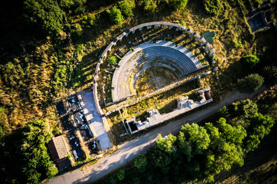
One of the characteristic monuments of the archaeological area of Ferento is undoubtedly the theatre built on the western sector of the plateau in two successive stages. The first dates from the early decades of the Augustan age (approx. 31-11 B.C.).The second can be dated between 150 and 170 A.D. by the style of the statues of the Muses and the beautiful statue of Desire (Pothos) that adorned the front of the stage, as well as a series of manufacturer’s stamps on the bricks of its walls, produced exclusively by the Victorini who were active in the Viterbo area in those years. Later renovations and expansions were carried out in the Severian period, between 196 and 204. The seating area (cavea) with a capacity of around 3,400 spectators, was partly cut out of the rocky slope of travertine marble to take advantage of the natural gradient. The highest level of benches (summa cavea), which is no longer extant, rested on a system of subterranean semi-circular brick corridors and was surmounted by round arches resting on pilasters of squared blocks of peperino volcanic tuff [link].
The baths were situated to the east of the theatre. They were constructed in the first decades of the 1st century A.D. and modified several times. The layout, with three entrances from the decumanus maximus, consisted of a large swimming pool (natatio) enclosed by a portico, followed by a pair of twin large areas with mosaic floors in black and white. They have been interpreted as changing rooms (apodyteria). They were followed by the usual succession of cold room (frigidarium) with two large quadrangular bathing tubs, a warm room (tepidarium) and a hot room (caldarium), terminating on the southern side in an apsidal hall. The area for women was on the eastern side, while the central heating area and other technical facilities (praefurnia) were located in the south-eastern corner.
The amphitheatre and a house beside the decumanus
No archaeological investigations of the amphitheatre for public entertainment have been conducted, but the large ellipse of its structure can be seen in aerial photographs of the north-eastern sector of the plateau. The constructional technique of the building, which was partially carved out of the rocky hillside, resembles that of the amphitheatres of Pompeii and Telesia in Campania and should be dated to the late Republican era (2nd-1st centuries B.C.), while analysis of the material found points to its destruction, for as yet unknown causes, in the Claudian era (41-54 A.D), or at the latest during the early years of Nero’s reign (54-68 A.D.)
West of the theatre, the excavations of the 1950s brought to light the remains of a residence (domus) with a large central courtyard (atrium) [link], with a portico on the side facing the decumanus, from the late Republicanperiod (133-31 B.C.). It was modified in the Julio-Claudian period (14-68 A.D.). Next to this residential unit and adjacent to the theatre was a large three-nave public cistern from the same Julio-Claudian period. This impressive hydraulic system must have been supplied by the city aqueduct, built between the late Republican era and the Augustan period, i.e. between the 1st century B.C. and the first century A.D. Its route has been reconstructed for some three km, from Piscin di Polvere (where the first firm evidence for its existence is to be found) to the edge of the Roman city.
Giovanna Ottavianelli
classical philologist and archaeological epigraphist
ATTUALMENTE SI PUÒ VISITARE
- il decumanus maxìmus (E/O), l’asse principale dell’abitato che lo tagliava in direzione est-ovest;
- un pregevole impianto termale con pavimenti a mosaico ben conservati;
- il teatro formato dalla cavea, destinata gli spettatori, dalla scaena ove si svolgevano le rappresentazioni, dal fossato e da ben 27 arcate che circondano e decorano la parte posteriore alcune originarie dell’epoca altre rialzate e/o completamente o solo in parte ricostruite
- verso l’estremità orientale di Piancara si trova l’anfiteatro ancora non scavato e visibile solo in parte.
INFO UTILI
E' presente ampio parcheggio per le macchine in prossimità del sito archeologico.
Il sito archeologico di Ferento è raggiungibile tramite
Per pernottare e/o mangiare:
Per altre informazioni e approfondimenti, cliccare sul link https://viterbo.artecitta.it/area-archeologica-di-ferento/
ALCUNE FOTO DEI DINTORNI DI FERENTO DONATECI DA UN VISITATORE.


FOTO SCATTATE NEL SITO ARCHEOLOGICO DAI VOLONTARI DI FERENTO


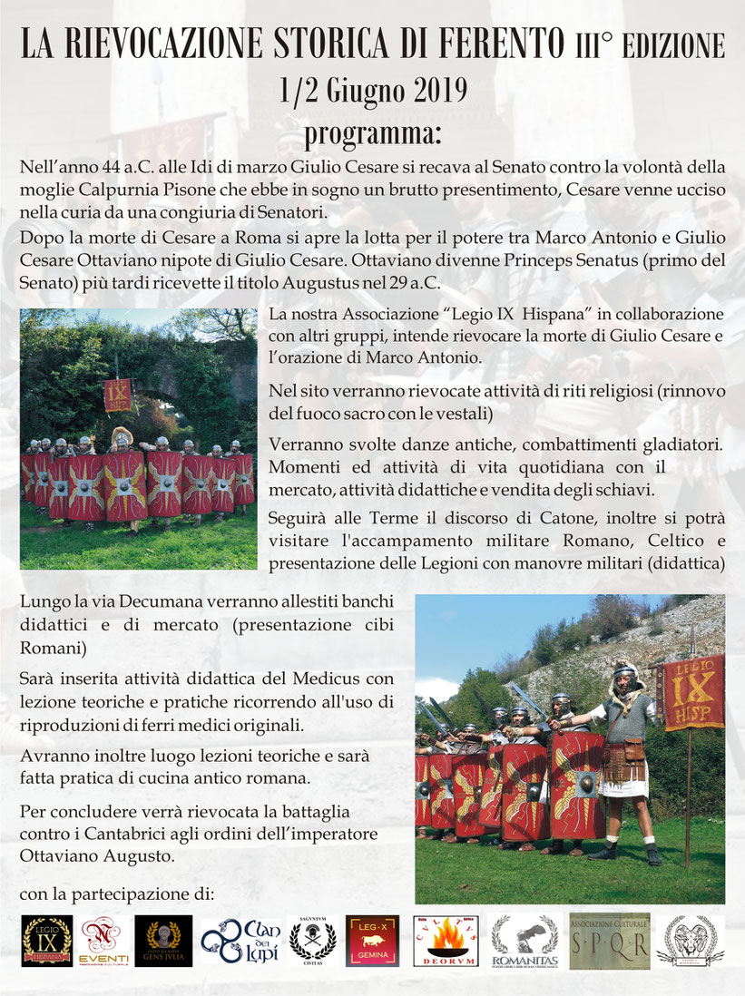
RIEVOCAZIONE STORICA DI FERENTO - 4 E 5 GIUGNO 2022

4 e 5 giugno 2022
Escluso i due giorni della rievocazione storica,
il sito Archeologico di Ferento è aperto escluso il lunedì a meno che non sia giorno festivo, con i seguenti orari che possono variare con le stagioni. Dal Martedì 14/14.30 alle 18/18.30 Sabato e Domenica dalle 10.30/11 alle 18/18.30
In estate la chiusura è 19/19.30 (orario e giorni apertura sono variabili nel periodo dal 15 luglio al 15 agosto perché il sito ospita nel teatro la stagione teatrale estiva)
Per qualsiasi informazione chiamare 3287750233 anche Whatsapp o mandare mail per info ad archeotuscia@gmail.com


FERENTO 6 GIUGNO 2021 DALLE 17.00 ALLE 20.00 PASSEGGIATE e INCONTRI CON GLI ANTICHI ROMANI. MOMENTI DI STORIA PER GRANDI E PICCINI.

LAVORI RIPULITURA DECUMANO


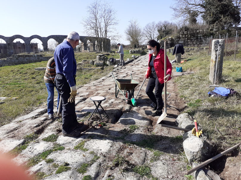


Grazie al lavoro di ripulitura dei volontari Archeotuscia, i mosaici delle terme di Ferento tornano a risplendere!


Prenotazione obbligatoria per le visite al sito di Ferento al n° 328.7750233 (Simonetta) o 335434366 (Michele)
La nuova brochure di ferento


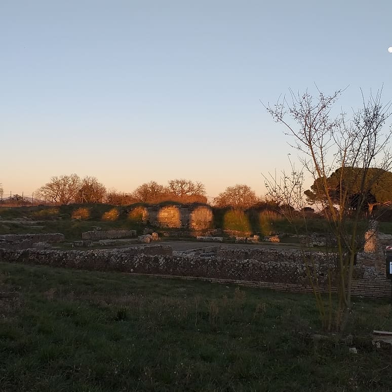
Ph Ruggero Arena http://www.ruggeroarena.com/ferento-2/
fonte testo
L.Proietti, M. Sanna, Tra Caere e Volsinii, Viterbo 2003
La nuova guida di Ferento


